
What Is GIS Survey and How Does It Work? A Complete Guide
In today’s digital world, accurate location data is essential for planning, development, and decision-making. A GIS survey combines geographic data collection, mapping technologies, and spatial analysis to create detailed digital maps and location-based insights. From urban planning and infrastructure development to environmental monitoring and disaster management, GIS surveys help organizations make informed decisions. This article explores what a GIS survey is, how it works, its key components, applications, benefits, and future trends.
What Is a GIS Survey?
A GIS survey is the process of collecting, analyzing, and managing geographic or spatial data using Geographic Information System technology. It captures location-based information and converts it into digital maps and datasets that can be analyzed for decision-making.
Unlike traditional surveys that focus only on measurements and boundaries, GIS surveys integrate location data with additional information such as population, land use, environmental conditions, and infrastructure details.
The primary goal of a GIS survey is to create an accurate digital representation of a geographic area that can be used for planning, monitoring, and analysis.
READ THIS ALSO: GIS SURVEY SERVICES
Understanding Geographic Information Systems (GIS)
Before understanding how a GIS survey works, it is important to understand GIS itself.
A Geographic Information System is a computer-based system that allows users to:
- Capture geographic data
- Store spatial information
- Analyze location-based patterns
- Visualize information through maps
- Generate reports for decision-making
Why GIS Surveys Are Important
GIS surveys provide valuable information that supports planning and resource management.
Some key benefits include:
Improved Decision-Making: Organizations can make informed decisions based on accurate spatial data.
Better Resource Management: GIS helps identify and manage land, water, forests, and infrastructure efficiently.
Accurate Mapping: Modern GIS surveys provide highly detailed and precise maps.
Enhanced Planning: Urban planners and engineers use GIS data for project design and development.
Risk Assessment: GIS helps identify areas vulnerable to floods, earthquakes, and other natural hazards.
Key Components of a GIS Survey
A GIS survey consists of several interconnected components.
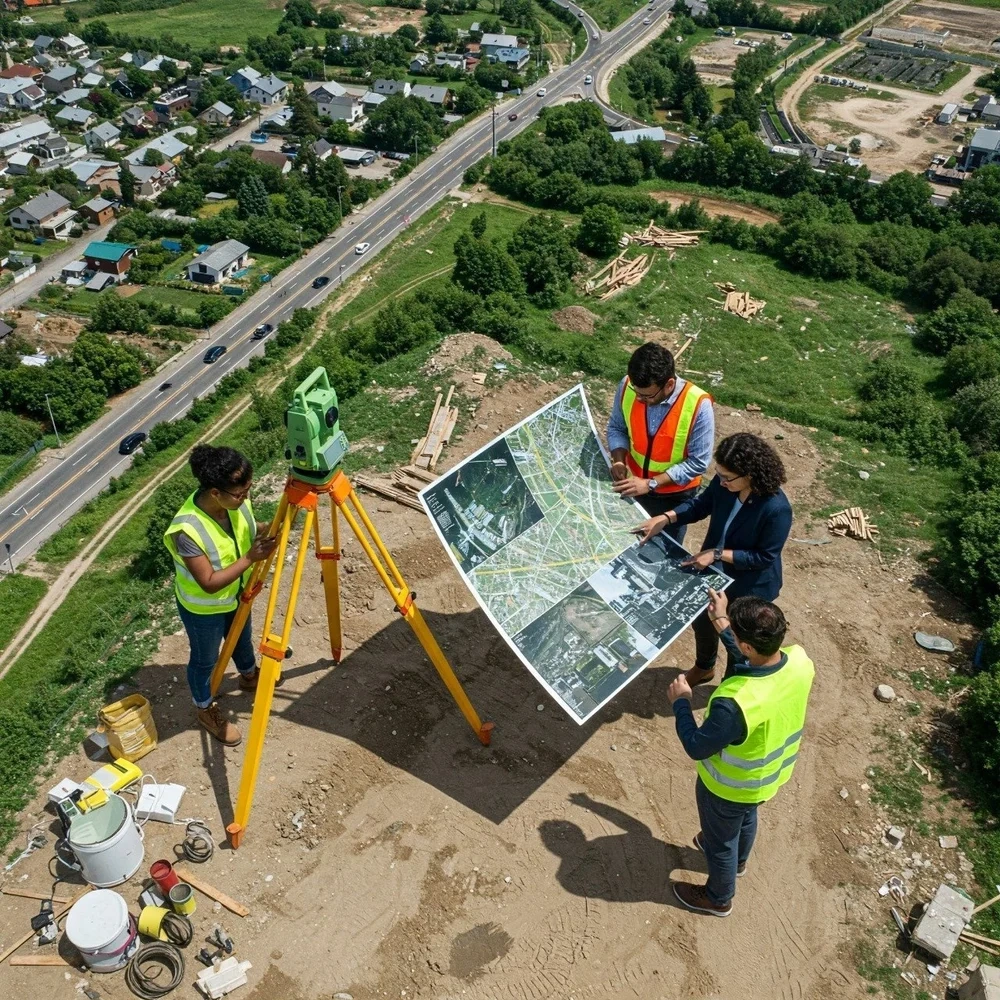
1. Data Collection: The first step involves gathering geographic information from various sources.
Common data collection methods include:
- GPS surveys
- Satellite imagery
- Drone surveys
- Field observations
- Remote sensing technologies
2. Spatial Data: Spatial data represents the location of geographic features.
Examples include:
- Roads
- Rivers
- Buildings
- Utility networks
- Land boundaries
3. Attribute Data: Attribute data provides additional information about geographic features.
For example:
| Geographic Feature | Attribute Information |
| Road | Name, Width, Surface Type |
| Building | Height, Ownership, Purpose |
| River | Length, Water Quality |
| Land Parcel | Area, Land Use Type |
| Utility Pole | Identification Number, Status |
4. GIS Software: Specialized GIS software is used to process and analyze collected data.
Popular GIS platforms include:
- ArcGIS
- QGIS
- GRASS GIS
- MapInfo
5. Data Analysis: The collected information is analyzed to identify patterns, relationships, and trends.
6. Map Visualization: The final output is presented through maps, dashboards, and reports.
How Does a GIS Survey Work?
A GIS survey follows a systematic workflow.
Step 1: Define Objectives
Surveyors first determine the purpose of the project.
Examples include:
- Mapping utility lines
- Planning a highway
- Monitoring environmental changes
- Managing city infrastructure
Step 2: Collect Geographic Data
Data is gathered using various technologies.
GPS Devices: GPS receivers record precise geographic coordinates.
Drones:Drones capture high-resolution aerial images.
Satellite Imagery: Satellites provide large-scale geographic coverage.
Field Surveys: Surveyors verify and collect information directly on-site.
Step 3: Process the Data
Raw data is cleaned, organized, and converted into usable formats.
This step removes errors and ensures data accuracy.
Step 4: Create GIS Layers
Different types of information are organized into layers.
Examples include:
- Road network layer
- Land use layer
- Population layer
- Utility infrastructure layer
Step 5: Analyze Spatial Information
GIS software performs spatial analysis to identify patterns and relationships.
Examples include:
- Finding the shortest route
- Identifying flood-prone areas
- Assessing land suitability
- Monitoring environmental changes
Step 6: Generate Maps and Reports
The analyzed information is presented through interactive maps and reports for decision-makers.
Types of GIS Surveys
Different projects require different types of GIS surveys.
Topographic GIS Survey: Maps natural and man-made features such as hills, roads, and buildings.
Land Use GIS Survey: Analyzes how land is utilized for residential, commercial, industrial, or agricultural purposes.
Utility GIS Survey: Maps underground and above-ground utilities.
Environmental GIS Survey: Monitors forests, water resources, wildlife habitats, and environmental conditions.
Transportation GIS Survey: Supports planning and management of roads, railways, and public transportation systems.
Cadastral GIS Survey: Records land ownership and property boundaries.
Applications of GIS Surveys
GIS surveys are widely used across industries.
Urban Planning
City planners use GIS to:
- Design transportation networks
- Manage land use
- Plan public facilities
Construction and Engineering
Engineers use GIS data for:
- Site selection
- Infrastructure design
- Utility mapping
Agriculture
Farmers and agricultural organizations use GIS for:
- Crop monitoring
- Soil analysis
- Irrigation planning
Environmental Management
GIS helps monitor:
- Forest resources
- Wildlife habitats
- Water quality
- Climate impacts
Disaster Management
GIS supports:
- Emergency response
- Flood mapping
- Risk assessment
- Evacuation planning
Telecommunications
Telecom companies use GIS for network planning and tower placement.
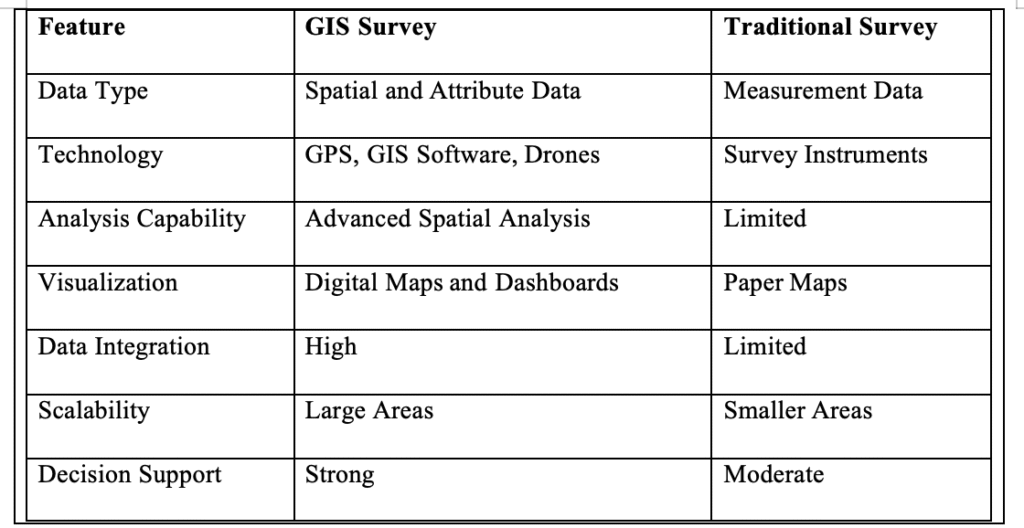
GIS Survey vs Traditional Survey
Benefits of GIS Surveys
Organizations increasingly adopt GIS surveys because of their numerous advantages.
Higher Accuracy: Modern GPS and satellite technologies improve measurement precision.
Faster Data Collection: Digital tools significantly reduce survey time.
Better Visualization: Interactive maps simplify complex information.
Cost Savings: Efficient planning reduces project costs.
Improved Collaboration: Multiple teams can access and share GIS data easily.
Enhanced Monitoring: Real-time updates improve project tracking and management.
Common Challenges in GIS Surveys
Despite their benefits, GIS surveys face several challenges.
Data Quality Issues: Inaccurate data can lead to incorrect analysis.
High Initial Costs: Advanced equipment and software may require significant investment.
Data Integration Complexity: Combining data from multiple sources can be challenging.
Technical Expertise Requirements: GIS systems require trained professionals for effective use.
Data Security Concerns: Protecting sensitive geographic information is essential.
Practical Example of a GIS Survey
Imagine a city government planning a new highway.
The GIS survey team:
- Collects satellite images of the proposed route.
- Conducts GPS field surveys.
- Maps residential areas and utility networks.
- Identifies environmentally sensitive zones.
- Analyzes traffic patterns.
- Generates route alternatives.
Future Trends in GIS Surveying
GIS technology continues to evolve rapidly.
Artificial Intelligence Integration: AI helps automate data processing and pattern recognition.
Drone-Based Mapping: Drones provide faster and more detailed geographic data collection.
Cloud GIS Platforms: Cloud technology improves collaboration and data accessibility.
Real-Time GIS Monitoring:Organizations can monitor infrastructure and environmental conditions instantly.
3D Mapping:Three-dimensional visualization enhances planning and design accuracy.
Smart City Development: GIS plays a central role in managing modern smart cities.
Actionable Tips for Successful GIS Surveys
To achieve the best results:
- Clearly define survey objectives.
- Use high-quality GPS equipment.
- Verify field data regularly.
- Maintain standardized data formats.
- Invest in GIS training for staff.
- Update geographic databases frequently.
- Implement strong data security measures.
- Use drones where appropriate to improve efficiency.
Schedule a free consultation today.
For inquiries, contact us at: grow@simbi.in