
GIS Data Collection Techniques: Methods and Best Practices
Two teams can survey the same site and walk away with datasets of very different value. The difference rarely comes down to effort. It comes down to whether the right technique was chosen for the accuracy the project actually needed, and whether it was applied with enough discipline to survive contact with real field conditions.
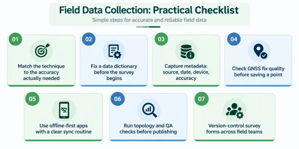
GIS data collection techniques are the specific methods used to capture location and attribute data before it is brought into GIS software: ground survey with GNSS or total stations, aerial capture with drones or LiDAR, satellite-based remote sensing, and mobile or crowdsourced field apps. Each has a different accuracy ceiling, cost profile and ideal use case, and most projects end up combining more than one.Choosing between them is not just a technical decision. A survey specified at a higher accuracy than the project needs wastes time and budget, while one specified below the required accuracy produces a dataset that cannot support the decisions built on it later. Matching the technique to the purpose is the first and most consequential step in any GIS project.
Choosing the Right GIS Data Collection Techniques
Technique selection usually comes down to four practical questions: how accurate does each feature need to be, how large is the area, how easily can it be accessed on foot, and what budget and turnaround time are available. A boundary dispute needs centimetre-level ground survey; a regional land-cover study is better served by satellite imagery than by sending survey teams into the field.
Core Data Collection Methods in GIS
The following methods cover most of what a GIS team is likely to use, individually or in combination:
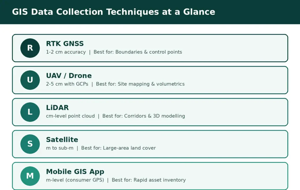
- Ground survey (GNSS and total station): differential and RTK GNSS receivers reach one-to-two-centimetre accuracy for boundaries and control points, while total stations remain the standard for engineering layouts.
- UAV/drone photogrammetry: overlapping aerial photographs are processed into orthomosaics and elevation models, reaching two-to-five-centimetre accuracy when tied to ground control points.
- LiDAR: laser-based scanning, whether airborne, vehicle-mounted or terrestrial, produces dense point clouds well suited to corridor mapping, forestry and 3D modelling.
- Satellite and aerial remote sensing: multispectral and radar imagery covers large areas quickly, at metre to sub-metre resolution, for land cover and change-detection work.
- Mobile and crowdsourced GIS apps: smartphones and tablets with consumer-grade GPS support fast, low-cost asset inventories and citizen-reported data collection.
- Digitisation of legacy records: scanned paper maps, old survey sheets and cadastral registers are georeferenced and traced into vector layers to extend a dataset’s history.
Data Collection Methods in GIS: A Practical View
In practice, the choice is rarely one method in isolation. A municipal roads project, for example, might use drone orthophotos to map pavement extent across the whole ward, RTK GNSS points to fix utility covers and junctions precisely, and a mobile app for field staff to log potholes and signage condition as they walk the route. The three datasets are captured differently but are designed from the outset to sit in the same coordinate system and attribute schema, so they merge into one usable layer instead of three incompatible ones.
READ AlSO : Best Tools for Field Data Collection in 2026
Common Mistakes That Undermine GIS Data Collection Techniques
- Choosing a technique for its familiarity rather than the accuracy the project requires.
- Flying drone missions without enough ground control points to validate the output.
- Mixing coordinate reference systems across teams or survey rounds without reconciling them.
- Treating data collection as a one-time exercise instead of building in a review and update cycle.
- Skipping a validation pass on crowdsourced or citizen-reported records before they enter the main dataset.
Advances in GIS Data Collection Methods
| Emerging technique | Practical application | Key benefit |
| AI-based feature extraction | Identifies roads, rooftops, and vegetation from aerial imagery | Reduces manual digitisation and speeds up mapping |
| Smartphone LiDAR | Captures detailed 3D information directly in the field | Makes advanced 3D data collection more accessible |
| Cloud-based GIS | Connects field and office teams to the same updated dataset | Enables near-real-time data sharing and reduces workflow delays |
| Integrated GIS workflows | Combines field observations, imagery, and digital datasets | Connects ground data with mapping and analysis more efficiently |
Choosing the Right Data Collection Approach for Your Project
Selecting between GNSS survey, drone capture, LiDAR, remote sensing and mobile field apps is easier with an experienced partner who has run each of them under real project constraints. Simbi Labs works with organisations to plan field surveys, select appropriate data collection methods in GIS, and set up mobile and digitisation workflows that produce datasets fit for the decisions built on them.
Book a free consultation for appointment
Email us at : grow@simbi.in
FAQs
1. What are GIS data collection techniques?
They are the specific methods used to capture spatial and attribute data in the field or from remote platforms, including GNSS survey, drone photogrammetry, LiDAR, satellite remote sensing and mobile field apps.
2. How do I choose between different data collection methods in GIS?
The choice depends on the accuracy the project needs, the size and accessibility of the area, and the available budget and timeline; higher accuracy generally means higher cost and slower coverage.
3. Which GIS data collection methods work best for large areas?
Satellite and aerial remote sensing cover large areas fastest, though at coarser accuracy than ground survey, drone capture or LiDAR, which are better suited to smaller, higher-precision sites.
4. Can multiple GIS data collection techniques be combined in one project?
Yes. Most projects combine methods, such as drone imagery for broad coverage with GNSS ground points for precise features, provided all datasets share a consistent coordinate system and attribute schema.
5. What is the most common mistake in GIS field data collection?
Choosing a technique based on familiarity or available equipment rather than the accuracy the project actually requires, which often surfaces as rework once the data is put to use.