
Data Collection in GIS: From Field Surveys to Digital Mapping
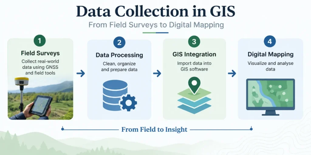
A digital map is only as reliable as the observations that built it. Behind every property boundary, road network, drainage layer or land-use map lies a chain of measurements taken on the ground, long before a single polygon appears on a screen. Poor positioning, incomplete attributes or inconsistent formats at this stage quietly reduce the value of every layer built on top of them.
Data collection in GIS covers the full sequence of activities used to capture location and attribute information and convert it into a structured spatial dataset. It brings together surveying, positioning technology, mobile data capture and database design so that a feature observed once in the field can be trusted, reused and analysed for years afterward.
Initiating GIS Field Data Collection
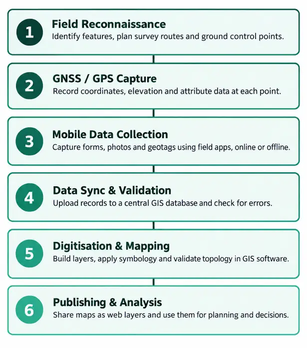
A survey begins with careful planning to define what to collect, the required accuracy, and how the data will be organised, including site reconnaissance, ground control, boundary and topographic measurements, attribute information, and geotagged photographic documentation.
READ AlSO : Best Tools for Field Data Collection in 2026
Methods Used for Geospatial Data Collection
Different sites and accuracy requirements call for different methods, and most GIS teams end up combining more than one.
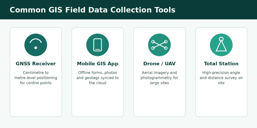
- Traditional instruments: total stations and differential GNSS receivers deliver survey-grade accuracy for engineering and cadastral work.
- GIS field data collection apps: smartphones and tablets with built-in GPS let field staff fill structured forms, capture photos and record coordinates without carrying separate equipment.
- Remote sensing and drones: UAV photogrammetry and satellite imagery cover large or hard-to-reach sites quickly.
- Crowdsourced collection: community or citizen-reported data adds rapid coverage over wide areas, provided it is validated before use.
GIS Mobile Data Collection in Practice
GIS mobile data collection has become the default approach for most field teams. Purpose-built apps let a surveyor complete a structured form, capture a GPS point and photograph a feature in one visit, then sync everything to a central database once network connectivity returns. This removes a step that used to introduce most transcription errors: copying handwritten field notes into a computer back at the office.
READ ALSO : Mobile-Based Survey Data Collection in India: Transforming Field Research in India
A number of established platforms are commonly used across GIS projects, each suited to a slightly different kind of fieldwork:
| Tool | Best suited for | Key strength |
| ODK / KoboToolbox | Large household or field surveys | Free, form-based, works fully offline |
| QField | QGIS-based field mapping | Syncs directly with existing QGIS projects |
| ArcGIS Field Maps | Enterprise GIS teams | Tight integration with ArcGIS Online |
| Mergin Maps | Small teams, quick field capture | Lightweight with simple version tracking |
Data Quality and Standards in Geospatial Data Collection
Geospatial data collection is only useful if different datasets can be combined without conflict. This depends on consistent coordinate reference systems, a clearly defined attribute schema, and metadata that records when and how each feature was captured. Open Geospatial Consortium (OGC) standards such as WMS, WFS and GML allow data collected in one software environment to be shared, queried and displayed in another without manual conversion.
In India, the Survey of India has been working with research partners to assess how consistently these standards are applied across government and private datasets, with the aim of building a national implementation plan that reduces duplication and improves interoperability between agencies.
From Raw Points to Digital Mapping
Once field data reaches the office, it still has to be turned into a usable map. Points, lines and polygons are imported into GIS software such as QGIS or ArcGIS, where topology checks catch gaps, overlaps and duplicate features before they cause problems downstream. Cartographic symbology is then applied so the map communicates clearly, and the finished layers are published as web services so they can feed dashboards, planning tools or public data portals.
Common Challenges in Field-to-Map Workflows
- GNSS signal loss in dense urban areas, forests or indoor sites, which reduces positional accuracy.
- Inconsistent attribute entry when different surveyors interpret a form field differently.
- Device storage and battery limits during long field days.
- Duplicate capture of the same feature when multiple teams work the same area without coordination.
- Sync conflicts between offline edits made in the field and updates made in the central database.
Digital Technologies and Practices for Reliable GIS Data Collection
| Technology / Approach | Application in GIS Data Collection | Key Benefit |
| AI-Based Feature Extraction | Automatically identifies roads, buildings, vegetation, and other features from aerial and satellite imagery. | Reduces manual mapping and the need for extensive ground surveys. |
| IoT Sensors | Collects real-time information such as water levels, air quality, temperature, and other environmental measurements. | Provides continuous and up-to-date data directly into GIS layers. |
| Cloud-Based GIS | Allows field and office teams to access, edit, and synchronize GIS data from a shared platform. | Supports near-real-time collaboration and reduces data duplication. |
| BIM and CAD Integration | Combines geospatial information with engineering, architectural, and infrastructure project data. | Improves coordination between GIS and engineering teams. |
| GNSS-Based Data Collection | Captures accurate geographic coordinates along with relevant feature attributes during field surveys. | Improves positional accuracy and supports reliable spatial datasets. |
| Mobile GIS Surveys | Enables field teams to collect geographic and attribute information using mobile devices. | Makes field data collection faster, structured, and easier to validate. |
| Attribute Schema & Validation | Defines required attributes and applies validation checks during or after data capture. | Improves data consistency, completeness, and long-term reliability. |
| Designed GIS Data-Collection Process | Establishes systematic procedures for capturing, checking, storing, and updating spatial data. | Ensures that GIS maps are based on trustworthy and well-structured datasets. |
Building a Reliable GIS Data Collection Workflow
Every layer in a GIS is a record of decisions made in the field: what to measure, how to measure it, and how to check it afterward. Simbi Labs works with organisations to design field survey protocols, mobile data collection systems and digital mapping workflows that hold up to real-world use, so that maps stay accurate long after the survey team has moved on.
Book a free consultation for appointment
Email us at : grow@simbi.in
FAQs
1. What is data collection in GIS?
It is the process of capturing location and attribute information in the field and converting it into a structured spatial dataset that can be stored, analysed and mapped in GIS software.
2. What does GIS field data collection involve?
It involves planning a survey, establishing ground control points, and recording the position and attributes of features using instruments such as GNSS receivers, total stations or mobile devices.
3. How does GIS mobile data collection work?
Field staff use apps on a smartphone or tablet to fill structured forms, capture GPS coordinates and attach photos, often offline, before syncing the records to a central GIS database.
4. Why does geospatial data collection need standards?
Consistent coordinate systems, schemas and metadata allow data collected by different teams or software to be combined and shared without manual rework, which is what OGC standards such as WMS and WFS are designed to support.
5. Which tools are commonly used for GIS field data collection?
Commonly used tools include ODK, KoboToolbox, QField, ArcGIS Field Maps and Mergin Maps, each suited to a different scale and type of fieldwork.