
GIS in Urban Planning: Applications, Benefits and Uses

Rapid urbanisation creates a planning problem that cannot be solved through conventional maps and tabular records alone. Urban planners must simultaneously evaluate land use, population density, transportation networks, drainage, utilities, environmental constraints, infrastructure and development pressure.
This is where GIS in urban planning becomes technically valuable. Geographic Information Systems connect each planning variable to its geographic location, integrate different datasets and enable spatial analysis before development decisions are implemented. GIS therefore functions not simply as a mapping platform, but as a spatial decision-support system for analysing existing conditions, evaluating alternatives and prioritising interventions.
READ THIS ALSO: GIS Survey Services | Accurate Mapping & GIS Solutions
GIS as a Spatial Decision-Support System
GIS supports urban planning by integrating different types of location-based information into a single analytical environment.
Key functions include:
- Data integration: Combines parcels, roads, buildings, land use, population, drainage, utilities and elevation data.
- Attribute analysis: Links spatial features with information such as road width, capacity, facility type and infrastructure condition.
- Spatial analysis: Identifies underserved areas, urban expansion patterns, suitable development locations and infrastructure gaps.
- Decision support: Helps planners compare locations, assess constraints and prioritise development interventions.
- Planning visualisation: Presents complex spatial relationships through maps and analytical layers.
The National Remote Sensing Centre identifies urban planning, infrastructure planning, facility planning and site-suitability analysis as key applications of geospatial technologies.
Core GIS Data Required for Urban Planning
The analytical quality of an urban GIS project depends heavily on the quality and compatibility of its input datasets.
| GIS dataset | Technical information represented | Planning application |
| Land-use/land-cover | Built-up, agricultural, vegetation and water classes | Land-use and growth analysis |
| Parcel/cadastral data | Plot boundaries, area and property information | Land management |
| Road network | Centre lines, hierarchy, width and connectivity | Transport analysis |
| Building footprints | Location, coverage and built form | Density assessment |
| Population | Population distribution and demographics | Facility planning |
| DEM/elevation | Height, slope and terrain | Drainage and suitability analysis |
| Drainage and water bodies | Rivers, streams and drainage channels | Flood-risk assessment |
| Public facilities | Schools, hospitals, parks and civic facilities | Accessibility analysis |
A critical technical consideration is spatial reference consistency. Datasets obtained from different departments may use different coordinate reference systems, scales, positional accuracies and update periods. These datasets must therefore be appropriately georeferenced, standardised and validated before spatial analysis.
READ THIS ALSO: What Is GIS Survey and How Does It Work? Powerful Guide
Land-Use and Urban Growth Analysis
Land-use analysis is a key application of GIS in urban planning. Satellite imagery can be classified into land-use/land-cover categories and integrated with administrative and infrastructure data to identify changes in built-up areas, vegetation, agriculture and water bodies.
Comparing multi-temporal datasets helps planners measure the direction, extent and pattern of urban growth, making it possible to identify urban sprawl and distinguish compact, corridor-based, peripheral or fragmented development. The NRSC urban applications programme highlights satellite-based monitoring for urban growth characterisation and planning.
Site Suitability and Development Potential
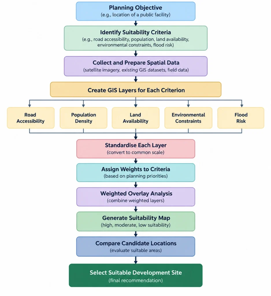
GIS-based suitability analysis helps planners identify appropriate locations by combining criteria such as road accessibility, population concentration, land availability, environmental sensitivity and flood risk.
These criteria can be standardised and combined using weighted overlay analysis, where each factor is assigned a weight based on its planning importance:
S = Σ (Wi × Xi)
Here, Wi represents the weight assigned to criterion i, while Xi represents its standardised suitability score. This produces a suitability map that supports transparent, evidence-based site selection rather than relying only on visual judgement.
Transportation and Accessibility Analysis
Urban planning in GIS also supports network-based transportation analysis. Unlike a simple circular buffer, network analysis considers the actual structure of the road or transport network. Planners can calculate shortest paths, service areas, travel distances and accessibility.
For example, a 1-km Euclidean buffer around a hospital assumes that people can travel directly in every direction. A network-based service area instead considers the roads through which people can actually reach the hospital.
This distinction is important in cities containing railway lines, rivers, restricted-access roads or disconnected neighbourhoods.
Public Facilities and Infrastructure Planning
GIS can identify gaps between population demand and existing service provision. Population-density surfaces can be overlaid with schools, hospitals, fire stations, parks and other facilities to conduct proximity and service-area analysis. Areas with high population but limited facility accessibility can then be prioritised.
The same principle applies to utilities. Water pipelines, sewer networks, electrical infrastructure and drainage systems can be represented as spatial assets and linked with information such as capacity, condition, installation year and maintenance status.
Environmental and Risk-Sensitive Planning
Urban development cannot be evaluated independently of environmental conditions. GIS enables planners to overlay proposed development areas with flood-prone zones, water bodies, wetlands, steep slopes, vegetation and other environmental constraints. Digital elevation models can additionally support slope, drainage and watershed analysis. This allows planners to identify areas where development could increase environmental or infrastructure risks before construction begins.
A Practical Urban Planning Example
Consider a municipality planning a new public healthcare facility in a rapidly expanding peripheral zone.
Rather than selecting a site based only on land availability, planners can map population density, existing hospitals, road networks, vacant parcels, flood-prone areas and land-use restrictions.
Network analysis can identify neighbourhoods with poor access to existing hospitals. A suitability model can then exclude restricted and flood-prone land while assigning greater weight to parcels close to major roads and larger population concentrations.
Suppose three candidate parcels remain after the initial screening. GIS can compare them using population coverage, accessibility, environmental constraints and distance from existing facilities. The final location is therefore supported by a reproducible spat.
GIS-Based Master Planning in India
GIS has moved beyond individual planning studies into formal master-planning programmes in India.
Under AMRUT, GIS-based master planning has involved geodatabase creation, master-plan formulation and capacity building. The National Remote Sensing Centre describes the development of urban GIS databases using high-resolution satellite data for use by Urban Local Bodies in GIS-based master-plan formulation.
This is significant because master plans require consistent spatial information covering land use, transportation, infrastructure and other urban characteristics. A structured GIS database provides a common spatial framework through which these components can be analysed together.
Remote Sensing, GIS and Urban Monitoring
Remote sensing and GIS perform complementary functions. Remote sensing provides repeated observations of the Earth’s surface, while GIS provides the environment for storing, integrating, querying and analysing those observations alongside other datasets.
For instance, satellite imagery can identify newly developed built-up areas, while GIS can determine which planning zones those developments occupy, their proximity to infrastructure and whether they extend into restricted areas.
This combination is particularly useful for urban growth monitoring, land-use change detection and infrastructure planning.
Emerging Technologies in Urban GIS
Modern urban GIS is increasingly shifting from static mapping towards dynamic and data-driven planning. Key technologies include:
- Web GIS: Enables online access, sharing and visualisation of spatial data.
- Cloud GIS: Supports large datasets and collaborative geospatial workflows.
- Mobile GIS: Enables field teams to capture and update georeferenced information.
- 3D City Models and LiDAR: Support detailed building, terrain and infrastructure analysis.
- UAV Surveys: Provide high-resolution data for site assessment and urban monitoring.
- IoT and Digital Twins: Support real-time infrastructure monitoring and urban simulation.
- Artificial Intelligence: Enables automated image classification, pattern detection and spatial prediction.
Reliable implementation still de
GIS Tools Used in Urban Planning
Different tools support different stages of urban GIS workflows:
- ArcGIS: Desktop GIS, spatial analysis, mapping and advanced geoprocessing.
- QGIS: Open-source GIS for mapping, spatial analysis and data management.
- PostGIS: Spatial database extension for PostgreSQL, suitable for managing large geographic datasets.
- Google Earth Engine: Useful for large-scale satellite imagery and multi-temporal analysis.
Tool selection should consider project scale, data volume, analytical requirements, interoperability and database architecture.
Conclusion
GIS in urban planning has evolved from digital map production into a comprehensive spatial analysis and decision-support framework. Its value comes from integrating land, infrastructure, demographic, environmental and transportation information and analysing their spatial relationships.
Through land-use change detection, suitability modelling, network analysis, accessibility assessment, infrastructure mapping and environmental evaluation, urban planning using GIS allows planners to evaluate alternatives using measurable spatial evidence.
The most effective GIS-based planning projects are therefore not defined by the number of maps produced, but by the quality of the underlying data, analytical methodology and planning decisions supported by those datasets.
Get Expert GIS Support for Urban Planning Projects
Need support with GIS database development, spatial analysis, suitability modelling, urban growth assessment or GIS-based planning research? Simbi Labs provides technical research support for GIS, remote sensing, spatial analysis and data-driven urban planning projects.
Book a free consultation for appointment
Call Now : +91 99505 66669
Email : grow@simbi.in
FAQs
What is GIS in urban planning?
GIS in urban planning is the use of geographic information systems to integrate, analyse and visualise spatial data for land-use, infrastructure, transportation, environmental and development decisions.
What are the major applications of GIS in urban planning?
Major applications include land-use mapping, urban growth monitoring, site-suitability analysis, transportation planning, public facility allocation, infrastructure management, environmental assessment and master-plan preparation.
What is the role of remote sensing in urban GIS?
Remote sensing provides current and historical observations of land-use, built-up areas, vegetation, water bodies and other surface characteristics. GIS integrates these observations with planning and infrastructure datasets for spatial analysis.
Why is GIS useful for site selection?
GIS allows multiple criteria such as accessibility, population demand, land availability, environmental constraints and existing infrastructure to be evaluated simultaneously through spatial analysis and suitability modelling.
Is GIS used for master planning in India?
Yes. GIS-based master planning has been incorporated into Indian urban-planning initiatives, including GIS-based master-plan activities associated with AMRUT.