Types of GIS Services: A Complete Guide to Applications and Benefits
A boundary drawn two metres off, a pipe mapped on the wrong side of a road or a flood layer built on outdated terrain can each cost a project far more than the map ever did. That is why the quality of GIS services matters as much as their price. This guide breaks the types of GIS services down by what they produce, the methods behind them and the situations where each one earns its place.
Inside Geographic Information System Services: Data, Methods and Deliverables
Geographic Information System services work on two kinds of spatial data. Vector data stores points, lines and polygons, such as a manhole, a road centreline or a land parcel, each carrying attributes in a table. Raster data stores values on a grid of cells, as in satellite images, elevation models and rainfall surfaces. Every layer also needs a coordinate reference system, and mixing layers that use different systems is one of the most common causes of features that appear to sit in the wrong place.
A complete engagement usually runs as a chain: acquiring data through surveys, imagery or existing records; cleaning it, which includes fixing geometry errors and aligning coordinate systems; analysing it; and handing it over as maps, geodatabases and files such as shapefiles, GeoJSON, GeoPackage or GeoTIFF with metadata that explains source and accuracy. The method at each link decides how far the final map can be trusted.
READ MORE: GIS Remote Sensing Services for Accurate Mapping
Why Location Intelligence Pays Off
The value of GIS data analysis comes from combining layers that were never designed to be read together. Five effects show up repeatedly in project work.
- Hidden relationships surface: a spatial join between complaint records and a drainage layer can show that most waterlogging reports sit within a few metres of one blocked outfall.
- Constraints are found early: overlaying a proposed corridor on land use, slope and protected areas exposes conflicts while the route can still move cheaply.
- Field effort is targeted: mapped asset condition lets crews visit the worst-ranked sites first instead of working through a list in street order.
- Change becomes measurable: comparing layers from two dates turns a vague sense of growth or loss into area figures per zone.
- Evidence is easier to defend: a documented method with a dated, sourced map holds up better in a review, audit or dispute than an informal sketch.
The market reflects this reliance. MarketsandMarkets puts the global geographic information system market at roughly USD 11.8 billion in 2025, rising at 8.4 percent a year to about USD 28.6 billion by 2036, with urban planning and smart city projects as the largest application.
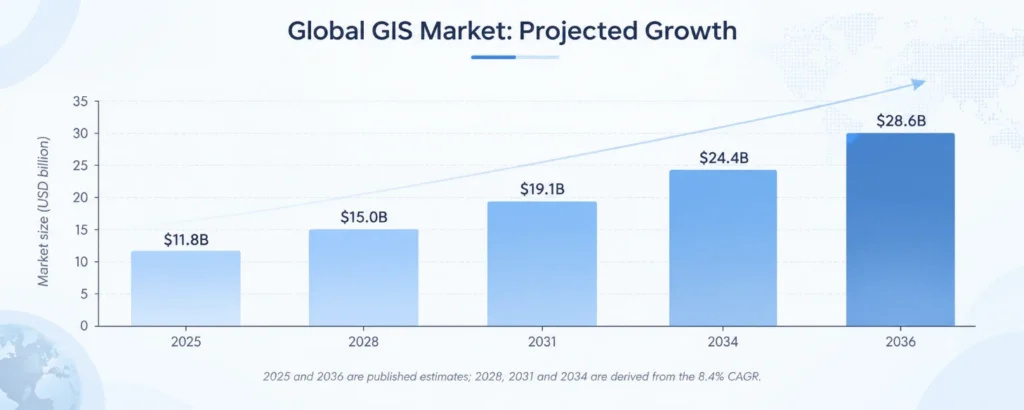
Figure 1: Projected growth of the global GIS market, 2025 to 2036 (Source: MarketsandMarkets; intermediate years derived from the stated CAGR).
Core Types of GIS Services and What Each One Produces
The types of GIS services differ in the data they start from and the product they hand back. Real projects typically combine two or three.
- GIS mapping services: cartographic production that turns raw layers into readable maps, with deliberate choices about symbols, classes and scale so the map answers one question clearly. Typical outputs are thematic maps, asset maps and web maps.
- GIS data analysis: the analytical layer: buffers, overlays, spatial joins, kernel density for hotspots, service-area and network analysis, and weighted suitability models. The output is a ranked, measurable answer rather than a picture.
- Remote sensing and image analysis: classification of land cover, vegetation indices such as NDVI and change detection between image dates, useful where ground access is slow or the area is large.
- Survey and field data collection: GNSS and GPS capture of locations, attributes and photographs. Phone-grade GPS typically gives metre-level positions, while survey-grade GNSS with correction methods such as RTK can reach centimetre level, so the accuracy target should be set before fieldwork.
- Utility and infrastructure mapping: building connected network layers for roads, drainage, water, power and telecom, where topology rules check that lines meet at nodes and flow directions make sense.
- Cadastral and boundary mapping: digitising and reconciling parcels against survey records, with attention to legal accuracy and the rules that govern land records.
- GIS consulting services: design of the data model, standards, software choice and update workflow, so an organisation keeps a maintained system after the first project ends.
GIS Services in Practice: Workflows by Industry
What separates industries is less the software than the question being asked of the data. The table shows the method typically used and what the client receives.
| Industry | Workflow and Method | What the Team Receives |
| Urban planning and smart cities | Weighted overlay of slope, flood risk, road access and land value to score parcels; growth modelling from past land-use change | Suitability map and ranked parcel list |
| Utilities and telecom | Network tracing on mapped pipes, cables and poles; field-verified condition attributes linked to each asset | Asset layer that supports outage and maintenance planning |
| Agriculture | Vegetation index time series (such as NDVI) from satellite imagery compared across seasons and plots | Zone maps showing stressed or underperforming areas |
| Environment and forestry | Change detection between image dates to separate real land-cover loss from seasonal variation | Change map with area statistics per zone |
| Transportation and logistics | Least-cost path and corridor analysis that weighs gradient, land use, crossings and right-of-way | Candidate alignments with length and constraint counts |
| Disaster management | Hazard layers overlaid with population, buildings and critical facilities to measure exposure | Risk zoning map and exposure tables for response plans |
| Retail and real estate | Drive-time catchments joined to demographic and competitor data | Ranked sites with catchment profiles |
In each case GIS mapping services present the result, but the decision-making value sits in the analysis step that precedes it.
Selecting a GIS Partner: A Six-Step Path
Good GIS consulting services begin with the decision, not the software. Figure 2 shows the path, and the points below add the questions worth asking at each stage.
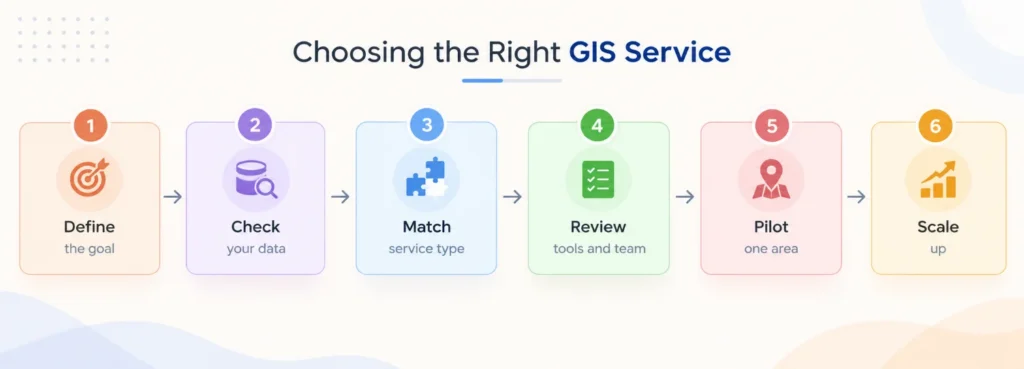
Figure 2: A six-step path for choosing the right GIS service.
Define the decision goal and acceptable error, check existing data quality and coordinate systems, select services based on required accuracy and scale, review tools, team responsibilities and data formats, pilot one area against ground truth, and establish update schedules, version control and access rules for long-term reliability.
Simbi Labs’ GIS Survey and Mapping Support
Simbi Labs provides GIS services including mapping and surveying, land and topographic surveys, GPS-enabled field data collection, utility and infrastructure mapping, urban planning support and construction progress monitoring. Deliverables include digital and thematic maps, geospatial datasets and spatial analysis prepared for planning and decision-making.
Frequently Asked Questions
1.What do GIS services include?
They cover the full chain from data acquisition through cleaning, analysis and presentation, so a typical package includes field or satellite data capture, a structured geodatabase, spatial analysis and finished maps.
2. How accurate is data from GIS mapping services?
It depends on the capture method. Phone-grade GPS is typically accurate to a few metres, while survey-grade GNSS with correction methods can reach centimetre level. Decide the accuracy needed before fieldwork starts.
3. Which file formats do GIS services deliver?
Common deliverables are shapefiles, GeoPackage, GeoJSON and file geodatabases for vector data, GeoTIFF for rasters, and PDF or web maps for presentation. Agree formats and metadata in advance.
4. How is GIS data analysis different from making a map?
A map shows information. GIS data analysis measures and compares it, for example by scoring sites, calculating exposed buildings in a flood zone or finding clusters, and then maps the result.
5. When are GIS consulting services worth it?
They pay off when a team lacks a defined data model, is choosing between tools, or needs a workflow that keeps maps current, because one-off maps age quickly without an owner and an update plan.
6. What types of GIS services are right for a small project?
Most small projects need two of the types of GIS services: field data collection to capture the ground, and mapping or analysis to present it. Consulting can come later if the work becomes recurring.