GIS and Remote Sensing: Basics, Applications and Benefits
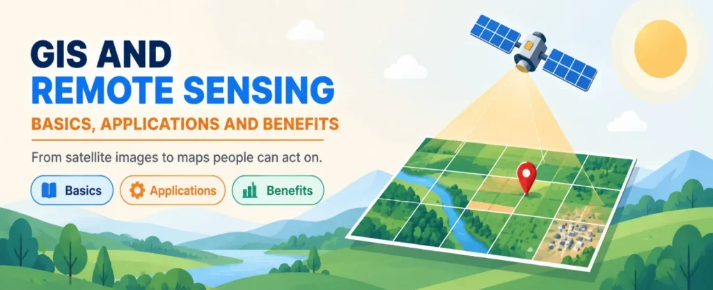
A satellite image on its own shows what the ground looked like. A map in a GIS shows what the ground means. GIS and remote sensing bring the two together, so that imagery can be measured, compared and turned into decisions. This article covers the basics of remote sensing and GIS, explains remote sensing in GIS, and shows how applied GIS and remote sensing is used in agriculture, planning and disaster response.
READ MORE: Advanced Remote Sensing And Satellite Imagery Services
Basics of Remote Sensing and GIS
Remote sensing is the process of collecting information about the Earth’s surface without touching it. Sensors on satellites, aircraft or drones detect energy that is reflected or emitted from the surface. That energy is a form of electromagnetic radiation, and different surfaces such as water, soil and vegetation reflect it differently.
A geographic information system, or GIS, is software and a method for storing, managing, analysing and mapping data that has a location. The basics of remote sensing and GIS are easiest to understand as a partnership: remote sensing collects imagery, and GIS organises, analyses and presents it.
| Feature | GIS | Remote Sensing |
| Main purpose | Store, manage, analyse and map spatial data | Capture information about the Earth from a distance |
| Typical data | Vector layers, tables, rasters, survey points | Satellite, aerial and drone imagery |
| Typical output | Maps, spatial analysis and reports | Images, land cover and change detection |
| Role together | Analyses and combines data | Supplies up-to-date imagery |
How Remote Sensing Works
Figure 1 shows the basic idea. An energy source lights up the surface, the surface reflects or emits energy, and a sensor records it. The recorded data is then processed and brought into a GIS.
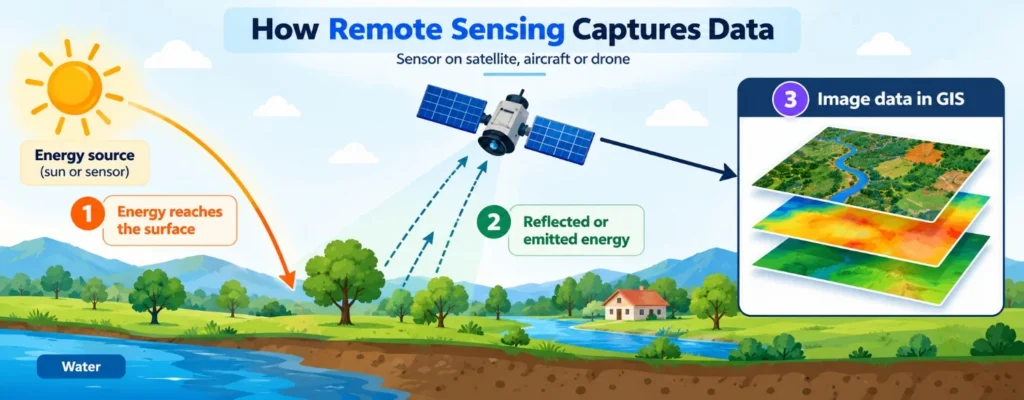
Figure 1: How a sensor captures data and passes it to a GIS.
Passive and active sensors
Passive sensors measure energy that comes from another source, usually reflected sunlight, so they generally need daylight and a clear sky. Active sensors send out their own signal, often microwaves, and measure what comes back. Active sensors can work at night and are less affected by weather.
Four types of resolution
When choosing imagery, four types of resolution decide whether it suits your project.
| Resolution | What it means | Example |
| Spatial | The smallest detail a sensor can capture, usually in metres | 30 m resolution gives 30 x 30 m pixels |
| Spectral | The range and number of wavelength bands recorded | Multispectral sensors record a few bands, hyperspectral hundreds |
| Temporal | How often the sensor revisits the same place | Landsat revisits roughly every 16 days |
| Radiometric | How finely the sensor detects differences in reflectance, measured in bits | Higher bit depth shows more variation |
Remote Sensing in GIS: How the Two Work Together
Remote sensing in GIS usually follows the workflow shown in Figure 2. Imagery is acquired, corrected, classified into useful categories such as water, vegetation and built-up land, and then overlaid with other GIS layers. The final step is a map, report or dashboard that supports a decision.
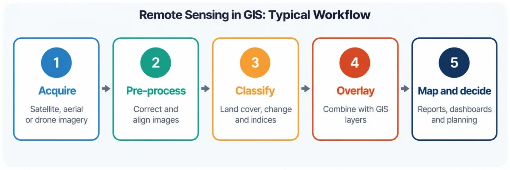
Figure 2: A typical workflow for remote sensing in GIS.
Overlay is where GIS adds the most value. For example, a land cover map from imagery can be combined with road, boundary and population layers to find areas that need attention first.
Field work still matters. Reference points collected on the ground help to check classification results, and our guide to GIS field data collection explains how that data is captured.
Applied GIS and Remote Sensing: Key Applications
Applied GIS and remote sensing supports work in many sectors. The most common areas are listed below.
| AgricultureCrop health, field boundaries, irrigation and yield estimates. | Urban planningLand use, built-up growth, roads and infrastructure planning. |
| Disaster managementFlood and burnt-area mapping, damage assessment and response planning. | Forestry and environmentForest cover change, land degradation and habitat mapping. |
| Water resourcesWater bodies, wetlands, drought and watershed monitoring. | Transport and utilitiesRoute planning, corridor mapping and asset monitoring. |
GIScience & Remote Sensing as a Field of Study
GIScience & Remote Sensing is also the name of a peer-reviewed journal in this area, and the phrase is widely used for the field that studies geographic data, analysis methods and Earth observation together. Students and professionals follow research of this kind to learn new methods, such as machine learning for image classification, before applying them in practice. If you plan to cite a specific paper or journal, check its current scope on the publisher’s page.
Benefits of GIS and Remote Sensing
| Wide coverageOne image can cover large or hard-to-reach areas that are slow to survey on foot. | Repeat observationRegular revisits make it possible to track change over months and years. |
| Cost and time savingsImagery reduces the amount of fieldwork needed for broad-scale mapping. | Better decisionsCombining imagery with GIS layers gives planners evidence they can map and share. |
Challenges to Plan For
- Cloud cover can block optical imagery, so some projects need radar data or several image dates.
- High-resolution imagery can be costly, and large images need storage and processing power.
- Classification results need checking against ground reference data.
- Choosing the wrong resolution can make results too coarse or too costly.
- Staff need training in both image processing and GIS analysis.
How to Get Started
Begin with a clear question, then choose data and methods to answer it. The checklist below turns this into steps.
| Checklist for an applied GIS and remote sensing project | |
| 1 | Question defined: what decision will the map support? |
| 2 | Imagery chosen to match the needed spatial, spectral and temporal resolution |
| 3 | Imagery corrected and aligned to the project coordinate system |
| 4 | Classification checked against field or reference data |
| 5 | Results combined with GIS layers such as roads, boundaries and land records |
| 6 | Maps, metadata and limitations documented |
Conclusion
GIS and remote sensing are strongest together. Remote sensing gives wide, repeatable views of the Earth, and GIS makes those views measurable and useful. By learning the basics of remote sensing and GIS, and by checking results against real ground data, teams can apply GIS and remote sensing to practical problems with confidence.
Simbi Labs supports organisations with GIS mapping and field data collection. You can read about our GIS survey services or contact us to discuss your project.
Frequently Asked Questions
1.What are the basics of remote sensing and GIS?
Remote sensing collects information about the Earth from a distance using sensors, and GIS stores, analyses and maps that information along with other location data.
2. What is remote sensing in GIS?
It means using imagery from satellites, aircraft or drones as data inside a GIS, where it can be processed, classified and combined with other layers.
3. What is the difference between GIS and remote sensing?
Remote sensing is a way of capturing data. GIS is a system for managing, analysing and mapping data, including remote sensing data.
4. What is GIScience & Remote Sensing?
It is a field that studies geographic information science and Earth observation, and also the name of a peer-reviewed journal in the area.
5. Where is applied GIS and remote sensing used?
Common uses include agriculture, urban planning, disaster management, forestry, water resources and infrastructure planning.
6. Do I need field data if I use satellite images?
Yes, in most projects. Ground reference data helps to check that classification results are correct.
Sources
Royal Meteorological Society: An introduction to remote sensing.