
Machine Learning in GIS: Techniques, Applications and Benefits
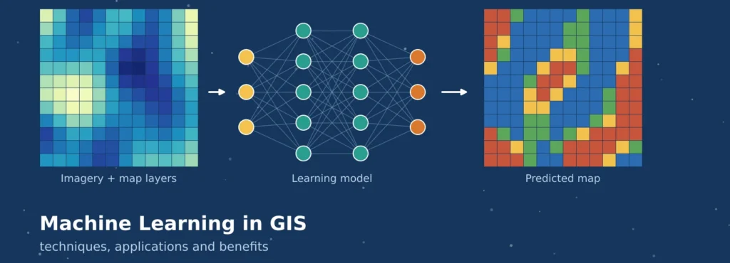
A city can have 100,000 buildings and a state can have millions of hectares of cropland. Hand mapping takes weeks, and is outdated until it’s completed. This is where the role of machine learning in GIS comes into play. A model is trained on labeled examples of what a roof looks like, and applies this knowledge to an entire region as new data comes in.
It’s not easy to do well as spatial data is of a different type than regular tables. This article provides an understanding of GIS machine learning, the relationship between Artificial Intelligence (AI) and Geographic Information Science (GIS) and how AI in GIS and GeoAI can be used to produce reliable outcomes. To read a short commercial overview, read the Nearmap article on machine learning in GIS.
READ MORE: Powerful Types of GIS Services for Smarter Decisions
Machine Learning in GIS: Meaning and Scope
The traditional GIS analysis is rule-based: The analyst writes the rule, for instance, “select parcels within 200 metres of a river,” and the software carries it out. Machine learning in GIS does the opposite. The algorithm is given examples and inputs, and the analysis determines the rule, in this case the combination of colour, texture and environment that defines an informal settlement from farmland, which is too complicated to write down manually.
The terms overlap. Machine Learning, Deep Learning and Computer Vision are under the broad umbrella of AI in GIS. GeoAI is the discipline that evolves spatio-explicit methods, i.e. methods that take location, distance and scale into account, as described in the paper GeoAI: spatially explicit artificial intelligence techniques. With machine learning in remote sensing, the same techniques are used on images captured by satellites, aerial and drone photography.
READ MORE: GIS and Remote Sensing: Basics, Applications and Benefits
Spatial Data Needs Special Care
- Spatial autocorrelation. Near things are more alike than distant things, so a model can score well by memorising a neighbourhood.
- Non-stationarity. Relationships change across space. Rainfall and crop vigour link differently in different agro-climatic zones.
- Scale effects. Results change with pixel size and with the zones used to aggregate data.
Spatially aware practice responds by adding neighbourhood and context features, testing models on geographically separate areas, considering regional models where relationships vary, and reporting uncertainty on the final map.
READ MORE: Expert GIS Mapping And Spatial Analysis Services
Core Machine Learning Techniques in GIS
Most tasks fall into four groups, shown in Figure 1: classification, regression, clustering and detection.
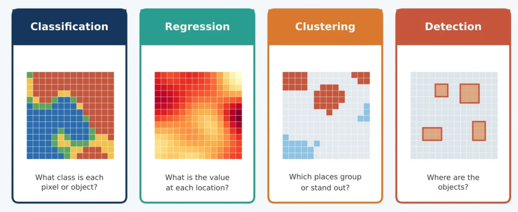
Figure 1: Four common machine learning tasks in GIS.
| Technique | Typical use | Note |
| Random Forest | Land cover, susceptibility maps, spatial prediction | Robust and quick; cannot extrapolate beyond training values |
| Gradient boosting | Continuous surfaces such as pollution or yield | Accurate; sensitive to tuning and leakage |
| k-means, DBSCAN | Grouping areas, clustering incidents | No labels; groups need interpretation |
| CNNs, U-Net | Object detection, building and road extraction | Need many labels and computing power |
| Local models | Relationships that vary across a region | Capture non-stationarity; harder to validate |
It is the most widely used classification task, which is supervised classification. The analyst gives the labelled points or polygons, the model learns the relationship between the points and the labels and classifies each unlabelled location. Satellite indices, elevation and land use are used as covariates to predict a desired variable, for example soil carbon, when there is lack of measurements. Deep learning brings in object detection, which outlines the vehicles or storage tanks, and segmentation to label each pixel to create footprints and field boundaries. The pre-trained networks can be fine-tuned with much less additional labelling for teams.
Machine Learning in Remote Sensing
Machine learning in remote sensing is the most mature branch of GeoAI, because imagery arrives in large, regular volumes, and Landsat alone offers an archive from 1972. Typical uses are:
- Land cover mapping from composites, indices and terrain layers.
- Crop mapping from vegetation index time series.
- Optical and radar fusion, which fills cloud gaps in monsoon regions.
- Change detection that separates clearing or construction from seasonal variation.
- Object extraction of buildings, roads and solar panels from high-resolution images.
Foundation models are the newest step. IBM and NASA released Prithvi, trained on Harmonized Landsat Sentinel-2 imagery, for fine-tuning to tasks such as flood and burn-scar mapping, described in the NASA Earthdata note. Local testing is still needed before its output is trusted.
Building a GIS Machine Learning Project
- Frame the problem. State the target, resolution, area and decision it supports.
- Prepare labels and imagery. Check labels for errors, since models inherit them. See GIS data collection.
- Engineer features. Add indices, texture, slope, distances and neighbourhood statistics. Context often helps more than a new algorithm.
- Train and tune. Watch for a large gap between training and test scores.
- Test with spatial independence. Hold out whole areas, not random points.
- Deploy and monitor. Models degrade when seasons, sensors or land practices change.
Utilities Across Sectors
- Urban planning: building footprints, land use and informal settlements, summarised by ward or block for planners. See GIS in urban planning.
- Agriculture: crop type, area and stress mapping from vegetation index time series, weather and soil layers.
- Environment: forest loss, wetlands and water bodies, tracked through time-series change detection.
- Disaster management: flood and landslide susceptibility from terrain, rainfall and land cover layers, and rapid damage assessment from before and after images.
- Public health and utilities: disease risk mapping with environmental covariates, and detection of poles, pipelines and rooftops.
Benefits of Machine Learning in GIS
Scale and speed are the primary benefits, consistent rules at all locations, ability to learn complex relationships among many layers, prediction when nothing was measured, and automation of repetitive digitising. A trained model is able to analyze thousands of square kilometres in hours and can be re-run for each new image, thereby allowing the comparison of maps from different dates. These rely on conditions: accuracy is dependent on the quality of the labels, and training areas must accurately reflect the target area to ensure accuracy and automated output still requires review.
Spatial Validation: A Worked Simulation
Randomly dividing points into training and testing set can make the results misleading since the test points next to the training points are close to training points. Blocked validation is recommended by Roberts and colleagues. In order to demonstrate the effect, we took a small smooth field, and sampled 1500 points. Random folds and 5 spatial strips (see Figure 2) were scored on a Random Forest. The data are fictional and have been developed for this article.
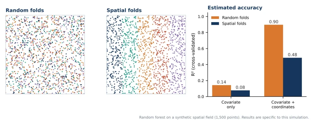
Figure 2: Random and spatial folds, and the cross-validated R² each gives (synthetic data).
With coordinates as inputs, random folds gave R² of 0.90, but spatial folds gave 0.48. With only a noisy covariate, the scores were 0.14 and 0.08. Random testing flattered the model, and new areas are where maps are usually needed.
Challenges and Best Practices
Main issues are the lack of accurate, but error-prone labels, spatial leakage, domain shift across different regions and sensors, classes that are rare and not captured by models, and the lack of interpretability and privacy of detailed images. Good practice answers each one of them. While complex models are difficult to explain such as using SHAP values to identify the most important inputs for the prediction, a model trained in one region should be fine-tuned with local samples before use in a different one.
- Begin with a simple baseline and invest in clean labels.
- Validate on held-out areas and report errors by class.
- Publish uncertainty beside the map, and test transfer before scaling.
- Document data, code and versions, and keep analysts reviewing a sample of the output, especially for high-stakes decisions.
Points Often Misunderstood
- More complex does not mean more accurate. A well-prepared Random Forest often matches a deep network when labels and features are the limit.
- A high accuracy figure is not proof of a good map. It must come from spatially independent test data.
- Coordinates as inputs can mislead. They let a model memorise places, which looks like skill but fails away from the training area.
- Predictions are estimates. A predicted map carries error and should be presented with it.
Conclusion
GIS and machine learning enable organisations to map greater areas, update maps in a quicker time frame and extrapolate conditions where measurement is not available. Spatial thinking and algorithms (representative labels, context features, honest validation and stated uncertainty) work best together. These principles are just as valid when applied to GIS machine learning for buildings, AI in GIS for risk or machine learning in remote sensing for crops, as they are in any other application. Groups that develop and test labels and location early spend significantly less time later defending a potentially successful model because they have already discovered why it failed in the field.
Simbi Labs India supports geospatial analysis, field data collection and mapping. Visit our contact page, book an appointment or reach us on WhatsApp.