
What Is GIS and How Does It Work? A Practical Guide to Geographic Information Systems
Geographic information is now central to planning, research, business, and public decision-making. GIS, or Geographic Information System, connects data with location to reveal patterns, relationships, and trends that may remain hidden in ordinary tables or spreadsheets.
The GIS full form is Geographic Information System. In practical terms, GIS meaning refers to a system that collects, manages, analyses, and visualises geographically referenced information. From urban development and environmental monitoring to transportation, healthcare, and agriculture, GIS turns location-based data into actionable insight.
READ THIS: GIS Survey Services
Geographic Intelligence: Beyond Maps and Locations
A map shows where something is. GIS goes further by helping users understand “why it is located there, how it relates to other features, and what patterns emerge across space”.
Imagine a city planning a new public hospital. The decision cannot depend on available land alone. GIS can combine population density, existing hospitals, road access, travel time, and land availability to identify areas with the greatest need. This ability to connect different datasets with geography represents the real value of a geographic information system.
The GIS Operating Framework
At its core, what is GIS and how does it work can be understood through a simple sequence:
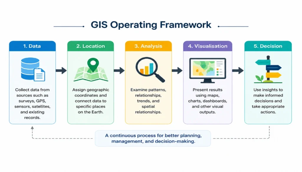
Geographic data is collected from sources such as GPS devices, satellites, drones, surveys, sensors, and government records. The information is then organised, processed, and analysed to identify spatial relationships. Finally, the results are presented through maps, dashboards, or other visual outputs that support informed decisions.
Read Also : Methods of GIS in Surveying and Mapping: Techniques, Analysis and Applications
The Five Elements Behind Every GIS System
A functioning GIS depends on five connected elements:
| Element | Role in GIS |
| Hardware | Computers, servers, GPS devices, drones, and mobile technology |
| Software | Mapping, data management, and spatial analysis |
| Data | Geographic and descriptive information |
| People | Analysts, planners, surveyors, researchers, and decision-makers |
| Methods | Processes and standards used to manage and analyse information |
From Raw Geographic Data to Spatial Insight
GIS converts raw information into a structured analytical process:
1. Data Collection: Geographic information is gathered from field surveys, GPS, satellites, drones, sensors, and other sources.
2. Storage and Management: Data is organised using geographic coordinates and databases.
3. Processing: Errors are corrected, datasets are standardised, and coordinate systems are aligned.
4. Spatial Analysis: Patterns, distances, relationships, and trends are examined.
5. Visualisation: Results are communicated through maps, dashboards, and other digital outputs.
This workflow allows geographic information to move from simple data collection to practical decision-making.
The Data Architecture of GIS
GIS becomes powerful when location and descriptive information are examined together.
- Spatial data represents where a feature is and what its shape looks like. It generally includes:
- Vector data: Points, lines, and polygons representing features such as hospitals, roads, rivers, and land parcels.
- Raster data: Grid-based information such as satellite imagery, elevation models, temperature, rainfall, and land-cover data.
- Attribute data, on the other hand, describes the characteristics of those features. A road may have information about traffic volume or speed limits, while a building may contain details about its height or function.
In simple terms:
“Spatial data tells you where and what shape. Attribute data tells you what it is like.”
GIS Mapping and Spatial Analysis in Practice
GIS mapping and spatial analysis are closely connected but serve different purposes.
Read Also : Adding Basemaps in QGIS using Plugins
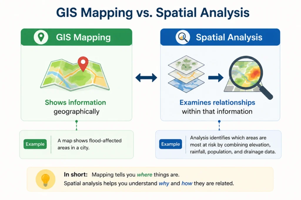
For example, a flood map may show affected areas, but spatial analysis can combine elevation, drainage, population, and infrastructure data to identify which communities face the greatest risk. This distinction allows GIS to move beyond visual representation and become a practical analytical tool.
GIS Across Real-World Decision Environments
GIS supports decision-making across a wide range of sectors:
| Sector | Key GIS Application | Decision or Outcome |
| Urban & Infrastructure | Land-use, facilities, roads, and utility analysis | Better site selection and development planning |
| Environment & Natural Resources | Forest, pollution, groundwater, and ecosystem monitoring | Identification of environmental change and priority areas |
| Agriculture & Land Management | Crop, soil, irrigation, and field-condition analysis | More targeted and efficient resource management |
| Transportation & Logistics | Route, traffic, and accessibility analysis | Improved mobility and operational efficiency |
| Healthcare & Public Safety | Disease, service-accessibility, and risk mapping | Better emergency response and service planning |
| Business & Location Intelligence | Market, customer, coverage, and site analysis | Stronger location-based business decisions |
GIS and GPS: Two Connected but Different Technologies
GIS and GPS are often confused, although they perform different functions.
| GIS | GPS |
| Manages and analyses geographic data | Determines geographic location |
| Supports mapping and decision-making | Provides coordinates |
| Combines multiple datasets | Collects location information |
GPS data can be collected in the field and later integrated into GIS for mapping and analysis. In this way, GPS can provide location information, while GIS provides the broader analytical environment.
The Professional Value of GIS
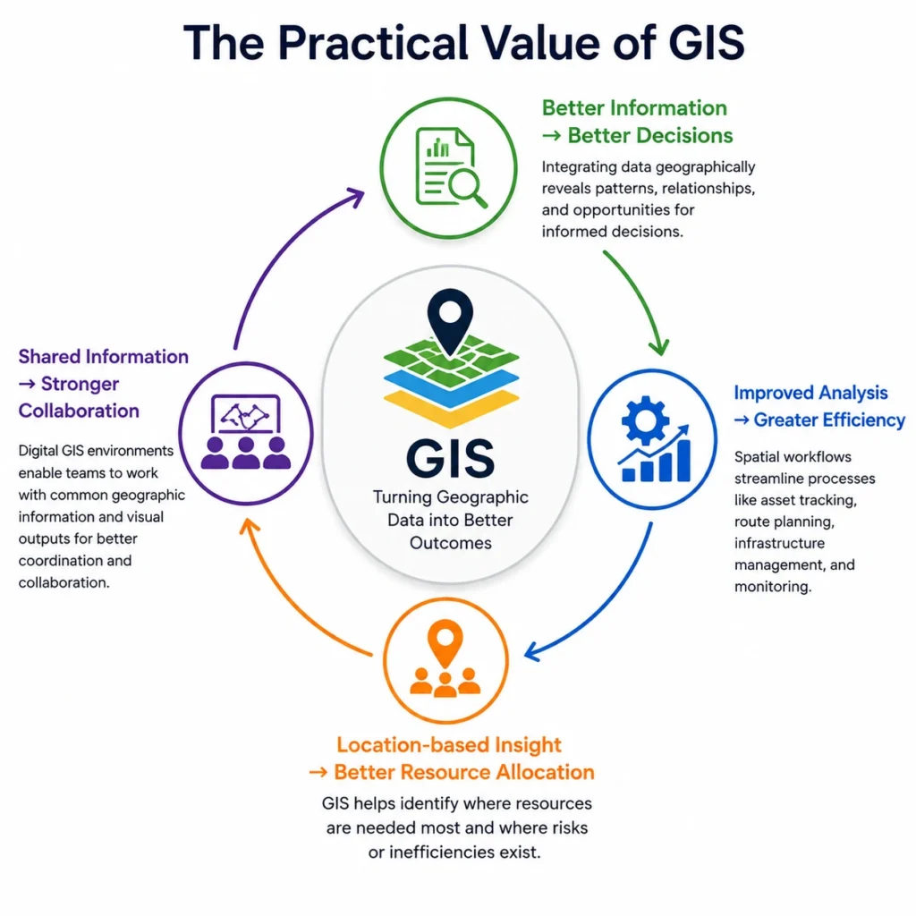
The practical value of GIS can be seen through its outcomes:
GIS Technology in an Expanding Digital Landscape
GIS is increasingly connected with other technologies, including cloud platforms, IoT networks, mobile applications, artificial intelligence, digital twins, and remote sensing.
These developments are expanding the capabilities of geographic information systems. Real-time sensors can continuously provide data, cloud platforms can support collaboration, and AI can assist with large-scale analysis and automated mapping. As industries become increasingly data-driven, the importance of location intelligence is likely to continue growing.
Read Also : GIS Survey Services in 2026: Technologies, Methods & Emerging Trends
A Simple GIS Decision Scenario
Consider a city planning a new hospital. Planners can collect population data from census records, existing hospital locations from GPS coordinates, and road network information from government mapping data or OpenStreetMap. Travel time and accessibility can then be analysed using GIS.
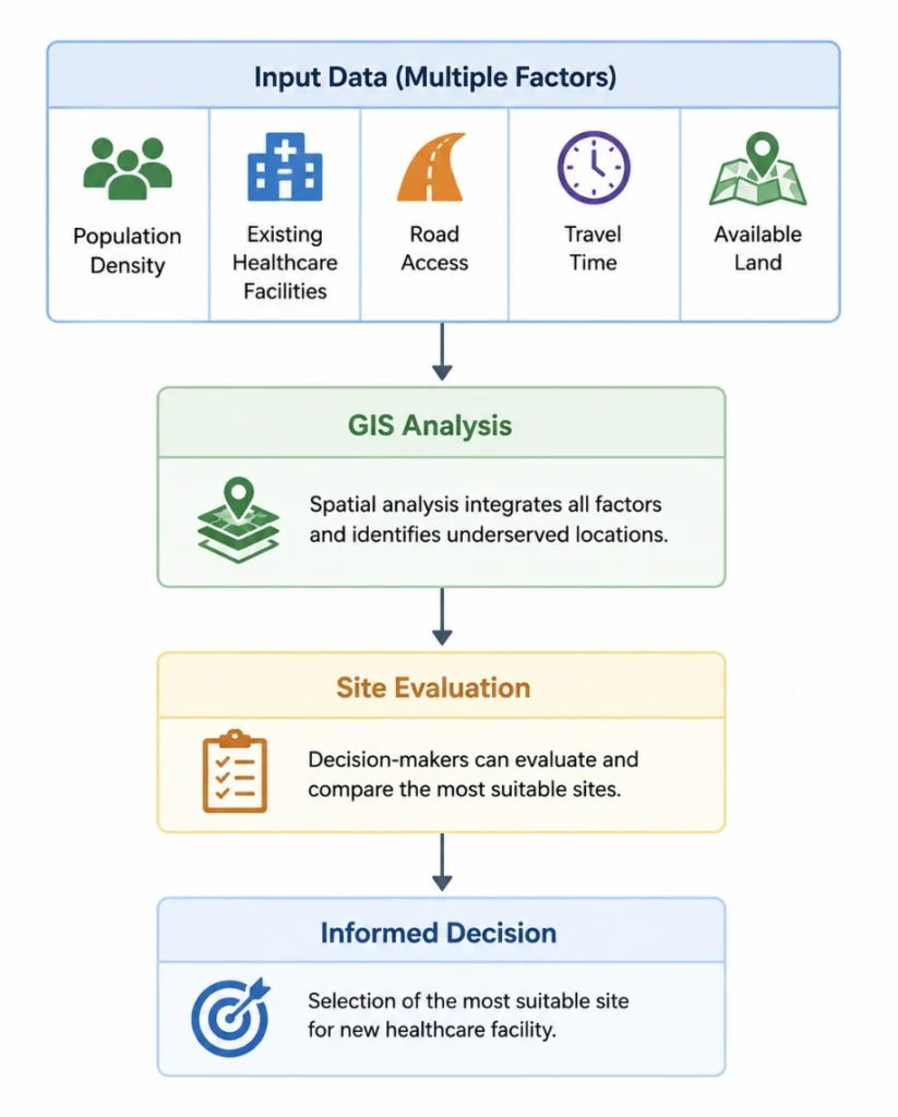
For example, GIS may reveal that a densely populated area has limited hospital access and longer travel times. Planners can compare available land and road connectivity in that area to identify a suitable hospital location.
This shows how GIS combines data from different sources with spatial analysis to support practical planning decisions.
The answer to what is GIS extends beyond the simple idea of digital mapping. A Geographic Information System creates a structured connection between data, location, analysis, and decision-making. Its ability to reveal spatial patterns makes it valuable wherever understanding where, how, and why something occurs can improve planning.
As geographic data continues to grow, GIS will remain an important tool for transforming location-based information into practical insight across research, industry, and public decision-making.
Book a free consultation for appointment
Email us at : grow@simbi.in
Frequently Asked Questions
1. What is the GIS full form?
GIS stands for Geographic Information System. It is a technology-based system used to collect, store, manage, analyse, and visualise information connected to geographic locations. GIS combines maps with different types of data, helping users understand spatial patterns, relationships, and trends.
2. What is GIS meaning in simple terms?
No. There is no official Turnitin plagiarism detector free version available for individual users. Students usually access Turnitin through their educational institution or licensed organization.
3. What is GIS and how does it work?
GIS works by collecting geographic data from sources such as GPS, satellites, surveys, sensors, and field observations. This data is stored and organised using geographic coordinates. GIS then analyses the relationships between locations and presents the results through maps, visualisations, or other outputs.
4. What is the difference between GIS and GPS?
GPS and GIS are connected but serve different purposes. GPS, or Global Positioning System, is primarily used to determine the geographic location of a person, object, or place. GIS uses location information, including GPS data, along with other datasets for mapping, spatial analysis, and decision-making.
5. What are the five components of GIS?
The five main components of a geographic information system are hardware, software, data, people, and methods. Hardware provides the technological infrastructure, software performs GIS operations, data provides geographic information, people manage and interpret the system, and methods guide the processes used for analysis.
6. What is GIS used for?
GIS is used wherever location-based information needs to be analysed or visualised. Its applications include urban planning, environmental monitoring, agriculture, transportation, disaster management, healthcare, business, infrastructure management, and scientific research. GIS is particularly useful when decisions depend on understanding spatial patterns and relationships.
7. Is GIS only used for making maps?
No. Although mapping is an important GIS function, the technology goes beyond visual representation. GIS can analyse distances, patterns, accessibility, spatial relationships, environmental change, and geographic risk. Maps are often the final output, but the underlying spatial analysis is what supports more informed decisions.
8. What types of data can be used in GIS?
GIS can work with many forms of geographic data, including vector data, raster imagery, GPS coordinates, satellite images, demographic information, environmental measurements, road networks, land-use records, and field observations. These datasets can be analysed together when they share a geographic reference or location.
9. Which industries use GIS?
GIS is used across many industries and professional sectors. Major applications include urban and infrastructure planning, environmental management, agriculture, transportation, healthcare, utilities, energy, mining, forestry, business intelligence, disaster management, and academic research.