
GIS Survey Services in 2026: Technologies, Methods & Emerging Trends
GIS survey services in 2026 combine spatial data collection, mapping technologies, positioning systems, remote sensing, and analytical tools to support accurate geographic decision-making. Modern GIS surveying services now use technologies such as GPS/GNSS, drones, LiDAR, mobile GIS, remote sensing, artificial intelligence, and cloud-based platforms.
These technologies support infrastructure, construction, urban planning, utilities, environmental monitoring, agriculture, and smart-city projects. The value of modern GIS survey solutions lies not only in collecting location data, but in transforming that data into reliable maps, models, and actionable spatial information.
READ THIS: GIS Survey Services
GIS Surveying: From Field Data to Spatial Intelligence
GIS surveying connects field-based information with geographic analysis. A typical project may involve:
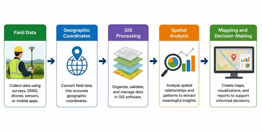
For example, during an infrastructure project, survey teams may collect the locations of roads, utilities, buildings, and physical features using GNSS devices or mobile applications. The data can then be processed in GIS to create accurate maps and identify relationships between project assets and surrounding areas.
This integrated approach makes GIS survey services valuable when projects require both accurate location information and analytical interpretation.
The 2026 GIS Survey Technology Landscape
Modern GIS surveying increasingly depends on combining multiple technologies rather than relying on a single survey method. The selection of technology depends on the project objective, required accuracy, site conditions, and available data.
| Technology | Primary Role | Practical Application |
| Drones/UAVs | Aerial GIS data collection | Large-area mapping and site monitoring |
| LiDAR | 3D terrain and feature mapping | Infrastructure and topographic surveys |
| GNSS/RTK/PPK | Precise positioning | Field surveying and control points |
| Remote Sensing | Large-scale observation | Environmental and land-use monitoring |
| AI-Assisted GIS | Automated data processing | Feature identification and classification |
| Mobile GIS | Field-based data capture | Asset and infrastructure surveys |
| Digital Twins | Digital spatial representation | Infrastructure planning and management |
| IoT Sensors | Continuous monitoring | Utilities and environmental observation |
- High-Resolution Data Collection Through Drones and LiDAR
Some surveys require rapid coverage of large or difficult-to-access areas, where drones and LiDAR are particularly valuable.
Drones capture aerial imagery for construction, agriculture, infrastructure, and environmental projects, while LiDAR provides detailed three-dimensional terrain and elevation data. Together, they strengthen GIS data collection where conventional ground surveys may be time-consuming or impractical.
- GNSS and Mobile GIS for Field-Based Surveying
Accurate field positioning is essential in GIS surveying. GNSS collects geographic coordinates, while RTK and PPK can improve positioning precision. Mobile GIS enables field teams to record coordinates, photographs, and observations directly on-site. For example, utility surveyors can map poles, pipelines, and inspection points with descriptive information, creating datasets for GIS mapping services, maintenance planning, and asset management.
- AI and Automation in GIS Survey Workflows
AI is increasingly being used to assist with large and repetitive GIS data-processing tasks.
For example, a project involving hundreds of aerial images may require the identification of roads, buildings, vegetation, or other visible features. AI-assisted methods can support feature detection and classification, reducing the amount of manual processing required.
However, automation does not remove the need for professional review. Survey quality still depends on data accuracy, methodology, control information, project conditions, and validation.
- Remote Sensing and Large-Area GIS Mapping
When the survey area extends across large geographic regions, remote sensing provides an important source of spatial information. Satellite imagery and other remotely collected datasets can support:
- Land-use and land-cover mapping
- Environmental monitoring
- Agricultural assessment
- Forest and vegetation analysis
- Water-resource studies
- Change detection
A planning authority, for instance, may compare imagery from different periods to understand how an urban area has expanded. GIS analysis can then connect this observed change with roads, population patterns, land availability, and infrastructure development.
- Modern GIS Survey Workflow
A modern GIS survey does not end when field data is collected. The process usually moves through several connected stages:
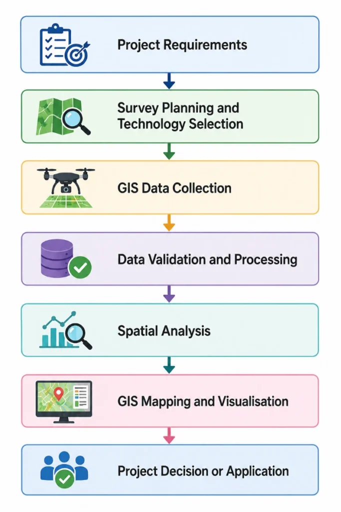
The workflow can be adapted according to project requirements. A cadastral survey, environmental study, construction project, or utility survey may use different technologies, but each depends on the structured integration of geographic data.
- A Practical GIS Survey Scenario
Consider a city planning a new urban development corridor. Survey teams may begin by collecting existing road and infrastructure information using GNSS equipment and mobile GIS applications. Drone imagery can provide an updated view of the development area, while satellite data can support broader land-use assessment.
The collected information is then integrated within GIS to analyse:
Existing infrastructure + land availability + road connectivity + terrain + surrounding development
This allows planners to identify potential constraints and opportunities before major development decisions are made.
The example demonstrates how GIS surveying combines multiple technologies and datasets to create a more complete understanding of a location.
Professional GIS Survey Services for Complex Projects
Professional GIS projects may require specialised support for survey planning, spatial data collection, GIS mapping, infrastructure surveys, utility mapping, environmental applications, and geospatial analysis.
The most suitable approach depends on the project objective and data requirements. Effective GIS survey services therefore require more than producing a final map; they involve selecting appropriate technologies, collecting reliable data, and developing outputs that can support practical decisions.
Simbi Labs provides professional support for GIS surveying, spatial data collection, GIS mapping, and geospatial solutions across research and project-based applications.
Frequently Asked Questions
1. What are GIS survey services?
GIS survey services involve collecting, managing, analysing, and visualising geographically referenced data. Depending on the project, they may use GNSS, GPS, drones, LiDAR, mobile applications, remote sensing, and GIS software to create maps and support spatial decision-making.
2. What technologies are used in modern GIS surveying?
Modern GIS surveying may use GNSS, RTK, PPK, drones, LiDAR, remote sensing, mobile GIS, cloud platforms, AI-assisted tools, and IoT-based monitoring systems. The technology selected depends on factors such as project scale, accuracy requirements, terrain, and the type of geographic information needed.
3. How are drones used in GIS mapping services?
Drones collect aerial imagery and other geographic data across survey areas. This information can be processed and integrated with GIS datasets to support site mapping, construction monitoring, land assessment, infrastructure surveys, and environmental applications.
4. What is the role of LiDAR in GIS surveying?
LiDAR uses laser-based measurements to capture detailed three-dimensional information about terrain and physical features. It is particularly useful for topographic mapping, infrastructure surveys, vegetation assessment, and projects requiring detailed elevation data.
5. How does AI support GIS survey solutions?
AI can assist with tasks such as image classification, feature detection, and large-scale data processing. It can improve workflow efficiency, particularly when projects involve extensive aerial imagery or remote-sensing datasets. However, professional validation remains important to ensure reliable survey outputs.
6. What is the difference between GIS surveying and traditional surveying?
Traditional surveying primarily focuses on measuring and establishing the position of physical features. GIS surveying integrates these geographic measurements with additional spatial and attribute data for mapping, analysis, visualisation, and decision-making. The two approaches can also be used together within the same project.
7. Why is GIS data collection important?
GIS data collection provides the geographic foundation for mapping and spatial analysis. Reliable location information allows organisations to understand where features are located, how they relate to one another, and how spatial patterns can influence planning, monitoring, and operational decisions.
Book a free consultation for appointment
Email us at : grow@simbi.in