
Digital Twin for Smart Cities: How Crowd Simulation Shapes the Future
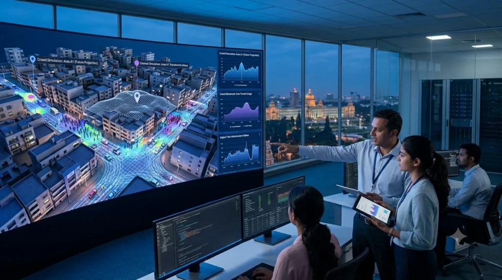
Imagine Testing an Entire City Before Building It
A city plans to build a new metro station expected to serve nearly 120,000 passengers every day.
The questions immediately arise:
- Will the station entrances handle morning rush hour?
- Could nearby roads become congested?
- Are pedestrian crossings sufficient?
- What happens if one entrance is temporarily closed?
- Can emergency vehicles still access the area during peak hours?
What are the consequences of closing one entrance for a short time? Are there any restrictions on emergency vehicles accessing during peak hours? These questions were traditionally addressed through traffic surveys, engineering assumptions and historical data. These methods were useful, but were not always able to reflect the behavior of thousands of people within the constantly changing urban environment.
With Digital Twin Crowd Simulation, they can build a virtual city “twin” that will help them simulate thousands of people and vehicles moving through the streets at the same time, test various scenarios, and see how they will affect the city before work
That’s why digital twins are quickly emerging as one of the most useful technologies in the field of Smart City Planning.
READ THIS: How AI Crowd Monitoring Improves Risk Detection and Safety
Why Traditional Urban Planning Is No Longer Enough
Cities are becoming more complex every year. Modern urban environments include:
- Multi-modal transportation systems
- Mixed-use developments
- High-rise residential towers
- Smart traffic signals
- Public transit hubs
- Large public gathering spaces
- Electric vehicle infrastructure
- Smart utility networks
Every new project influences the surrounding infrastructure. For example, adding a shopping mall doesn’t simply increase visitors, it also affects:
- Nearby intersections
- Bus stops
- Metro stations
- Parking demand
- Pedestrian crossings
- Emergency access routes
Planning these interactions manually is increasingly difficult. This is where digital twins offer a completely different approach.
What Exactly Is a Digital Twin?
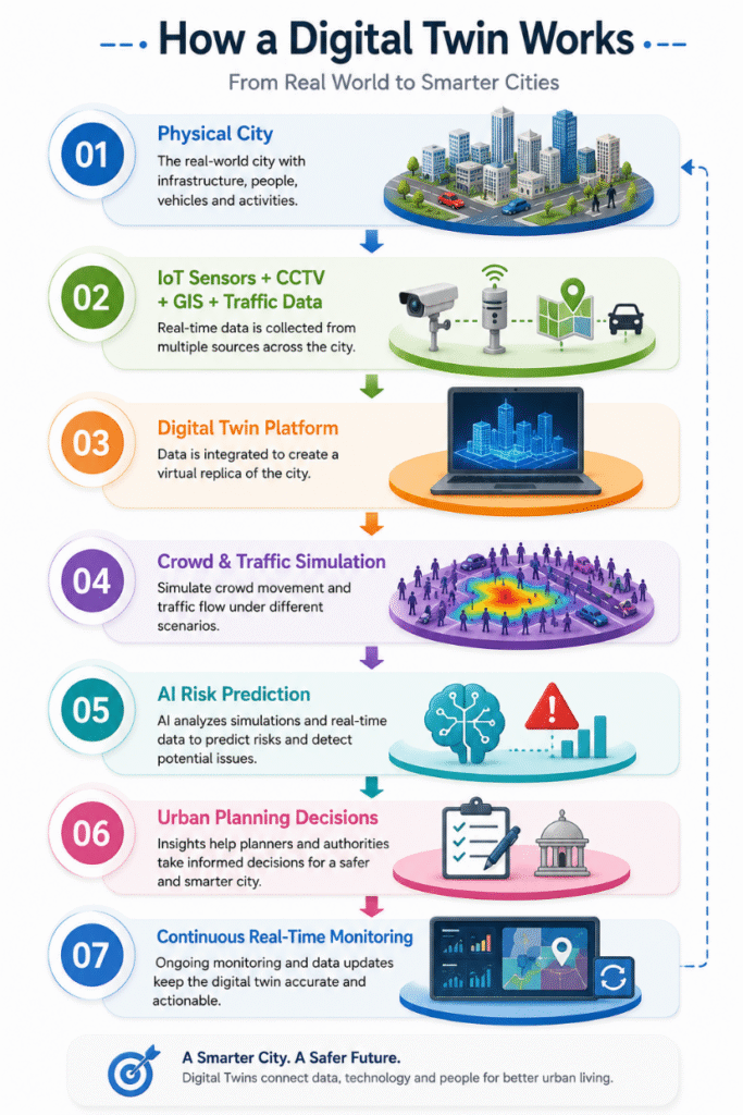
Think of a digital twin as Google Maps, Building Information Modeling (BIM), live CCTV feeds, IoT sensors, and AI-powered simulations—all working together in one intelligent virtual city model. A digital twin is a real-time data receiving 3D model, unlike a static 3D model. It updates itself using data from:
- Traffic cameras
- Smart street sensors
- GPS-enabled buses
- Weather stations
- Air quality monitors
- Public transportation systems
- Building Management Systems (BMS)
- IoT occupancy sensors
The model mimics actual conditions, enabling planners to make changes and experiments without affecting the actual city.
How a Digital Twin Works
Where Crowd Simulation Fits In
A digital twin shows what is happening now. Crowd simulation predicts what could happen next.
Digital twins and crowd simulation are a very powerful planning tool for today’s cities. They allow planners to simulate a variety of actual situations before they actually happen, such as power outages at metro stations, evacuating the populace during emergencies, planning the evacuation and response to floods, stadium traffic flow, airport passenger flow, pedestrian traffic on university campuses, and traffic flow on shopping malls during weekends. These scenarios can be tested in a virtual setting to identify potential bottlenecks, assess other options and optimise infrastructure and operational plans before deployment. Planners can address risk, enhance mobility and make cities safer and more efficient rather than wait until problems of congestion or safety have become an issue.
Five Ways Digital Twins Improve Smart City Planning
1. Smarter Urban Mobility
Mobility in the cities is one of the primary problems associated with urbanization where citizens face increasingly complex urban environments. With Digital Twin Crowd Simulation, urban planners have the ability to analyze and optimize pedestrian and transportation networks prior to physical interventions. Planners can simulate planning issues like sidewalk capacity, average walking times, bicycle travel, congestion at metro stations, bus terminal operations, pedestrian crossings, and public plaza use by developing a virtual model of the city.
These simulations show how people use urban infrastructure and infrastructure at different times and under different conditions, and help to identify bottlenecks and opportunities for improvement. A digital twin, for example, can show that a bus stop relocation by only 40 metres can help to enhance pedestrian mobility by around 30% and curb congestion. This level of information and insight, collected and analyzed, would be hard to achieve with traditional planning approaches, and can help cities make smarter, safer and more cost effective infrastructure decisions.
2. Better Emergency Preparedness
Emergency situations may be unpredictable and preparedness is one of the key features of smart city plans. By allowing authorities to build and simulate realistic emergency situations, including fire, earthquakes, flooding, chemical leaks, terrorist threats, power outages, and even large gatherings of people, Digital Twin Crowd Simulation lets them learn without disrupting real-world operations.
These events can be replicated in a virtual environment, which allows emergency planners to compare a number of different response plans, determine the safest routes for evacuation, identify any potential choke points, estimate the time it will take to evacuate, and establish the best location for emergency response teams and resources. This initiative is proactive and can help optimize the coordination between the emergency services, reduce response times and increase public safety during critical situations.
3. Data-Driven Infrastructure Investment
Making informed decisions is of the utmost importance when developing urban infrastructure, as it requires a lot of funds. City planners can use Digital Twin Crowd Simulation to forecast demand and study the potential effects of new developments on the environment before allocating the funding for roads, bridges, flyovers, metro stations, hospitals, or schools.
The traffic flow, pedestrian movement, and infrastructure usage can be evaluated to the planners through simulation models under various scenarios. If, for instance, a proposed road only moves congestion from one intersection to another, rather than less, then the design can be adjusted before construction commences. The data-based approach minimises expensive planning mistakes, optimises resource scheduling and guarantees infrastructure investments will have long-term benefits.
4. Improving Everyday Citizen Experience
The benefits of digital twins extend far beyond emergency management—they also enhance the daily lives of citizens. By continuously analyzing pedestrian movement, transportation systems, and public spaces, digital twins help planners optimize urban infrastructure to create a more convenient and efficient city. Improvements may include shorter walking distances, reduced waiting times at public transport stations, smoother traffic flow, better connectivity between different modes of transport, improved accessibility for people with disabilities, safer pedestrian crossings, and enhanced cycling infrastructure.
These improvements contribute to a more comfortable urban environment where residents can travel more safely, spend less time commuting, and enjoy better access to public services and amenities.
5. Supporting Sustainable Development
For cities looking to grow in a sustainable way while maintaining environmental responsibility, sustainability has become a major concern. Digital Twin Crowd Simulation helps achieve sustainable development by allowing planners to test and simulate the impacts of infrastructure and transportation decisions on energy usage, traffic, fuel consumption and carbon emissions.
Cities can use simulation to find out more efficient ways to move people, optimize public transport systems, limit excess growth of infrastructure, and reduce waste of energy. Multiple planning scenarios can be tested prior to implementation to allow decision makers to choose both the solution that will make the best use of the facility for efficient operation, and minimize impact to the environment. Therefore, digital twins are also playing a crucial role in contributing to achieving long-term sustainability objectives in cities and in making them healthier and more resilient.
Technology Behind Digital Twin Crowd Simulation
The success of a digital twin depends on integrating multiple technologies into a single ecosystem.
| Technology | Role in Smart City Planning |
| GIS (ArcGIS / QGIS) | Maps roads, utilities, land use, and pedestrian networks |
| BIM (Autodesk Revit) | Provides detailed building models |
| IoT Sensors | Collect live occupancy, traffic, and environmental data |
| AI Video Analytics | Detects crowd density and unusual behavior |
| Cloud Computing | Stores and processes city-scale datasets |
| Machine Learning | Predicts traffic demand and crowd patterns |
| 5G Connectivity | Enables low-latency real-time communication |
| Digital Dashboards | Supports operational decision-making |
Software Commonly Used
Different software platforms contribute different capabilities within a digital twin ecosystem.
| Software | Primary Application |
| GAMA Platform | Agent-based urban and pedestrian simulation |
| AnyLogic | Multi-method city and transport simulation |
| MassMotion | Pedestrian flow analysis in transit hubs and public spaces |
| Pathfinder | Building evacuation and emergency planning |
| Bentley iTwin | Infrastructure digital twin platform |
| ArcGIS | Spatial analytics and mapping |
| QGIS | Open-source GIS for urban analysis |
| Autodesk Revit | Building Information Modeling (BIM) |
| CityEngine | Large-scale 3D city modeling |
| NetLogo | Research and educational crowd behavior simulation |
Many smart city projects combine several of these platforms to create an integrated decision-support environment.
Case Study: Virtual Singapore – A City That Plans Before It Builds
Singapore has developed one of the world’s most advanced city-scale digital twins through its Virtual Singapore initiative.
The Challenge
As one of the world’s most densely populated countries, Singapore needed better ways to manage:
- Population growth
- Transportation demand
- Emergency planning
- Urban redevelopment
- Environmental sustainability
Traditional planning methods could no longer keep pace with the city’s complexity.
The Solution
The government developed a detailed 3D digital twin integrating:
- Building models
- Transportation networks
- GIS datasets
- Environmental monitoring
- Population movement
- Public infrastructure
Crowd simulation models are used to analyze pedestrian movement around transport hubs, evaluate redevelopment proposals, and support emergency preparedness exercises.
The Outcome
The platform has improved collaboration across government agencies, enabled evidence-based infrastructure planning, and reduced uncertainty when evaluating major urban projects. By testing proposed developments virtually before construction, planners can identify operational challenges early and make more informed investment decisions.
Looking Ahead: The Future of Smart Cities
Over the next decade, digital twins will become even more intelligent through advances in AI and connected infrastructure. Future capabilities may include:
- Autonomous traffic optimization
- Predictive crowd management for public events
- Climate resilience simulations
- Drone-assisted infrastructure inspections
- AI-generated infrastructure design alternatives
- Real-time city-wide operational dashboards
- Integration with autonomous vehicles and smart public transport
Rather than reacting to urban challenges, cities will increasingly anticipate and manage them before they affect residents.
Final Thoughts
Urban planning is moving to a new era of decisions made with real data, predictive analytics and virtual testing, instead of relying on assumptions only. Digital Twin Crowd Simulation can help planners assess infrastructure, transportation systems and public spaces before investing costly resources. Infrastructure developers, transport operators, municipal and urban planners have a role in making cities more efficient and safer, more resilient and ready for future growth by embracing this technology. The evolution of Smart City Planning will be accompanied by digital twins as a key component of urban planning and design, creating a city that is inclusive and sustainable, and prioritizes the needs of people, mobility and sustainability.
Book a free consultation for appointment
Email us at :grow@simbi.in